MPAtlas utilizes science-based assessments to categorize and measure the conservation benefits of marine protected areas across the globe using clear, standardized terminology.
MPAtlas utilizes science-based assessments to categorize and measure the conservation benefits of marine protected areas across the globe using clear, standardized terminology.
MPAtlas utilizes science-based assessments to categorize and measure the conservation benefits of marine protected areas across the globe using clear, standardized terminology.
Photo: Gregory Piper / Coral Reef Image Bank
30x30 (or 30 by 30) is the worldwide initiative and target to protect 30% of global land and ocean area by 2030. This goal has been adopted internationally as part of the Kunming-Montreal Global Biodiversity Treaty, as well as by individual countries and regions, such as the United States and the European Union. Scientific evidence suggests that 30% of the ocean must be effectively and equitably protected to safeguard marine ecosystems, halt the decline of marine biodiversity, build climate resilience, and support coastal communities. At Marine Conservation Institute, we support a 30x30 goal that includes fully or highly protecting 30% of the global ocean. Learn more about 30x30.
The World Database on Protected Areas (WDPA) is the official repository of terrestrial and marine protected area information. WDPA data is primarily self-reported by countries and official agencies, and it includes basic information, such as the location, area, spatial boundaries, governance type, and management authority, as reported for each site.
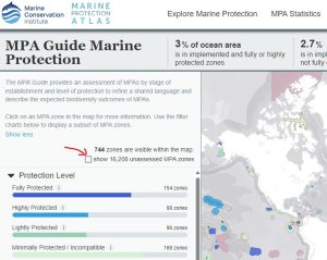
The Marine Protection Atlas hosts a complimentary dataset that uses the WDPA as a starting point. We build upon their data by conducting independent, third-party research and assessing MPAs and MPA zones using science-based frameworks, such as The MPA Guide and Regulation-Based Classification System (RBCS). These assessments allow us to systematically categorize MPAs by stage of establishment and level of protection, two metrics that help us estimate expected conservation outcomes. Learn more here.
Fully and highly protected areas are areas of the coastal or marine environment that allow minimal or no extractive or other damaging practices, such as fishing, mining, and oil and gas development. Studies have shown that fully and highly protected areas result in the greatest conservation benefits, while protected areas with less regulations and more human activities afford minimal conservation benefits. At Marine Conservation Institute, we aim to identify, measure, and recognize the MPAs that are most effectively contributing to biodiversity conservation and ocean health. You can learn more about fully and highly protected areas here and the science that supports them here.
You can view all reported MPAs by checking the box in the upper left-hand column of our online map.
Only a portion of the more than 18,000 MPAs reported to the World Database on Protected Areas (WDPA) have been assessed against The MPA Guide. We acknowledge many MPAs are missing from the MPAtlas database and welcome inquiries from experts who wish to add assessments on MPA sites and zones. We invite you to learn more about how to contribute to our database HERE. You can also email us directly at info@mpatlas.org.
MPAtlas often links our assessments to pre-existing geospatial data from the World Database of Protected Areas (WDPA). If you need the boundaries linked to our assessment of its effectiveness, you can use our download link HERE. If you are looking for only the boundaries or the MPA is only found in the WDPA reference layer but not our assessment database you can download directly from the WDPA at https://www.protectedplanet.net/.
First – thank you! Users like you who provided updated and corrected information on MPA sites, campaigns, and initiatives are invaluable to our work. We invite you to learn more about how to contribute to our database HERE. You can also email us directly at info@mpatlas.org.
The statistics reported by the WDPA and MPAtlas are complimentary, but they can differ because they are presenting the global picture of MPA coverage in different ways. The WDPA calculates its statistics from the MPA data self-reported by countries and includes all MPAs from the time of designation.
MPAtlas reports protected areas that are not only legally designated but are also fully implemented and providing conservation benefits on the water. We also track committed or proposed protected areas that have not yet achieved legal or authoritative recognition. MPAtlas also reports MPA coverage data by protection level. Specifically, we focus on fully and highly protected areas which afford the greatest conservation benefits.
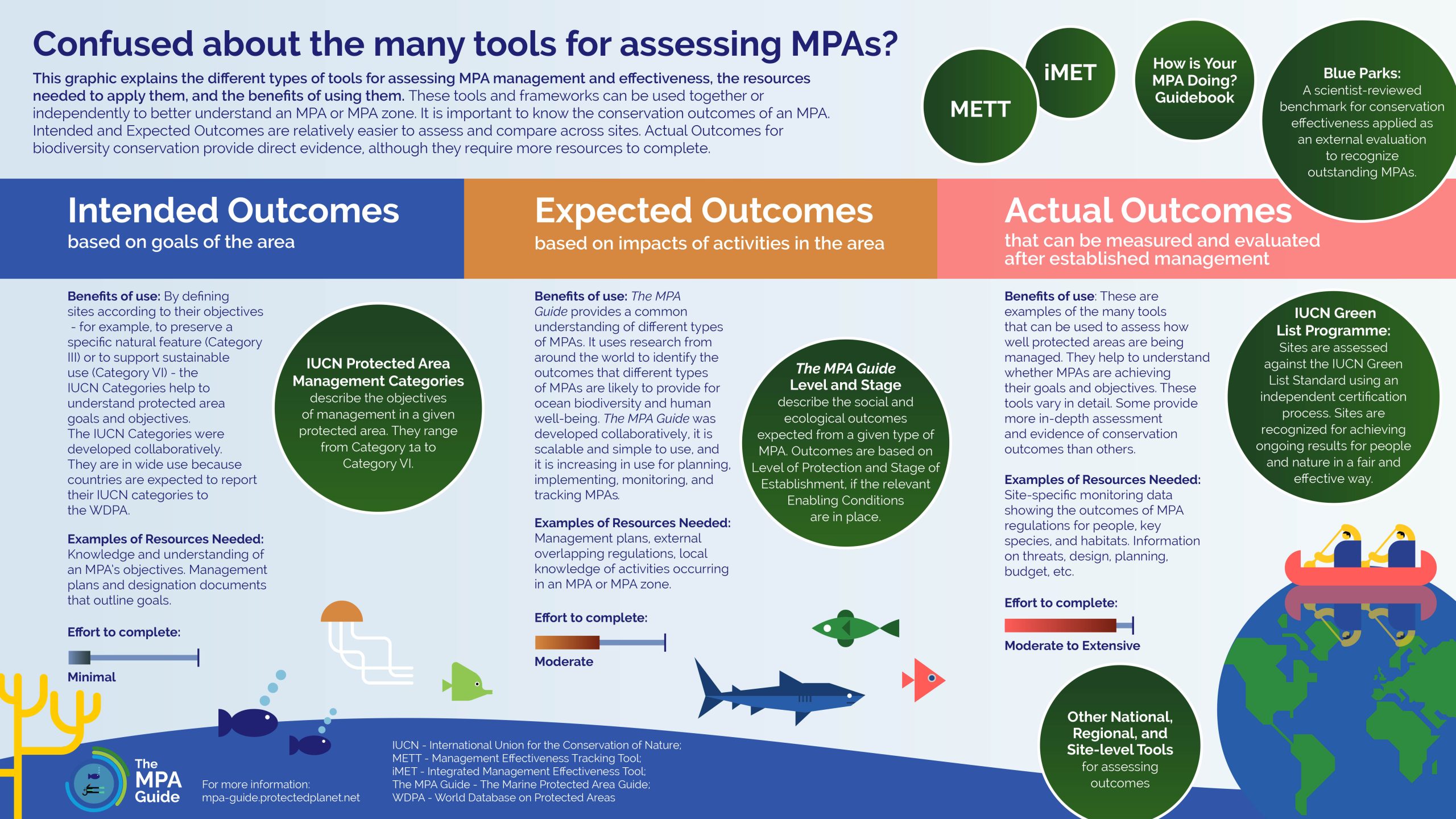
The MPA Guide is a science-based tool and framework to identify different types of MPAs and connect these types of MPAs with the outcomes they are expected to achieve. The MPA Guide consists of four elements: Stage of Establishment, Level of Protection, Enabling Conditions, and Outcomes. The MPA Guide links these elements to clarify what social and ecological Outcomes can be expected from an MPA at a particular Stage and Level, assuming the Enabling Conditions are in place.
Since all MPAs are different and some terms (e.g. marine reserve) mean different things in different places, The MPA Guide helps us estimate the conservation outcomes that can be expected from a given MPA or MPA zone and use clear, consistent terminology to describe that. The Marine Protection Atlas uses the MPA Guide to add more nuance to MPA data for reporting and tracking progress toward conservation goals.
Yes! Only a portion of the more than 18,000 MPAs reported to the World Database on Protected Areas (WDPA) have been assessed against The MPA Guide. We acknowledge many MPAs are missing from the MPAtlas database and welcome inquiries from experts who wish to add assessments on MPA sites and zones. We invite you to learn more about how to contribute to our database HERE.
We’re also always happy to meet with interested partners to provide tutorials, tours of our data entry platform, and chat about questions and potential projects. You can also email us directly at info@mpatlas.org.
The MPA Guide is not intended to make a value judgement for any type of MPA. Each MPA presents different challenges and has different goals. For example, some MPAs are located in areas that are more highly populated than others and some sustain communities. That means trade-offs are needed to balance social and conservation benefits. Each MPA is respected for its circumstances and evaluated specifically with biodiversity conservation in mind.
MPA assessments and their application to global MPAs are also very new. The MPA Guide is one of the first efforts to aggregate a comprehensive list of impacts that determine the conservation outcomes of MPAs. An MPA’s current score does not have to be the final answer – rather, we hope this is the beginning of a process. MPA assessments can help us unpack the reasons for an MPA’s status, uncover larger national or regional trends, and direct additional support to where it’s needed most. We hope that applying The MPA Guide to MPAs across the globe will allow us further refine and expand the Marine Protection Atlas (MPAtlas) and that, moving forward, the MPAtlas and The MPA Guide will be used as tools for holistic conservation planning that achieves conservation objectives and outcomes.
A protection level of Unknown/TBD simply means that the protection level is not currently known. Unknown and TBD (To Be Determined) are grouped together on MPAtlas maps for simplicity because they both share this basic meaning. However, they slightly differ in that Unknown is used for MPAs that are implemented or actively managed, while TBD is used for MPAs that are designated or proposed. This distinction is important because for implemented MPAs, the regulations and human impacts that occur in the MPA are established, and the necessary information to determine the level of protection was not available. In contrast, for many MPAs that are designated or proposed, the regulations and management for the MPA haven’t yet been established.
Using The MPA Guide, level of protection for an MPA or MPA zone is determined using a decision-tree framework that assesses the impact of seven human activities. In addition to categorizing MPAs by their overall level of protection, the MPAtlas interactive map provides the option to filter MPAs based on the impact of a single activity. For example, if you are only interested in the impact of fishing, you can filter based on Fishing Protection. Learn more about how to assess level of protection using The MPA Guide.
In some areas, multiple MPA designations overlap. These designations often come from different entities and may provide different or complementary features, such as regulations, durability, or resources. When you click on a given location on MPAtlas, all designations at that location will be shown.
While some MPAs are made up of a single uniformly-regulated area, many MPAs utilize zoning plans to coordinate competing use patterns, stakeholder groups, and conservation objectives. Zoning plan are developed using a combination of environmental, social, and economic data. MPA zones delineate where particular human activities are and are not allowed within a given MPA, resulting in a spatial separation of different resource uses.
For MPAs with multiple zones, the Marine Protection Atlas team and its partners assess each MPA zone individually. We do this because each zone has unique regulations, which can confer different protection levels and associated conservation benefits. For example, a no-take zone will provide more conservation benefits to an area than a multiple use zone that allows several types of fishing gear to be utilized.
IUCN Protected Area Management Categories are based on management objectives, whereas the protection level categories derived from the science-based assessments used by MPAtlas are based on an MPA's in-force regulations and the impact of associated activities. It’s a matter of intent versus what occurs in practice.